Silver Trail Mapping Expedition Succeeds!
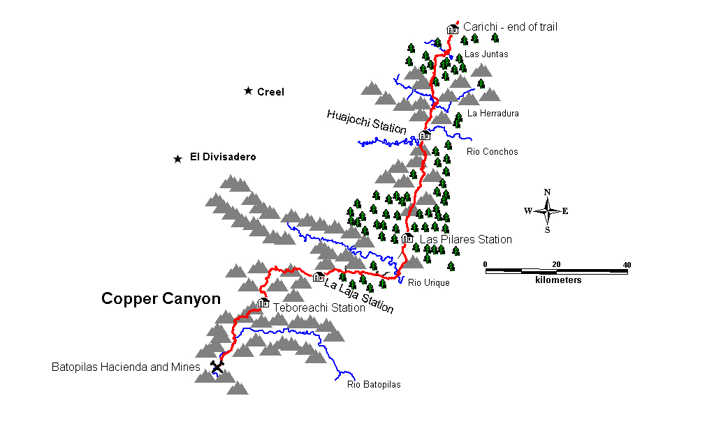
Locater Map:
Overview:
In a project completed in November, 2004, a group of Mexican and
US adventure guides re-discovered and
mapped the lost Copper Canyon Silver Trail. The trail reaches from
Mining in Copper Canyon dates back to the Spanish occupation when silver was discovered in 1632. The mines were among the richest in the world, and were operated off and on after the Spanish withdrawal and the subsequent takeover by the French leading to their defeat in1867. At that pivotal time, U.S. investors became actively involved in the mines around Batopilas. One such investor was John Robinson, who discovered a large silver deposit but lacked a means of transporting the ore out of the canyon.
In 1880 Alexander Shepard, the Governor of Washington DC was thrown out of office because of massive overspending on some public projects. He declared bankruptcy in the US, and moved his family to Batopilas to run a silver mine that he had purchased from Robinson. Over the next 26 years, Shepard's mine operations netted, refined, and exported 27 million ounces of pure silver. During that period, Shepard installed many unique improvements to the infrastructure of Batopilas. He constructed a full processing mill for the ore so that pure silver could be hauled out instead of ore. He built a aqueduct to furnish water and a hydroelectric plant, making Batopilas the second city in Mexico to have electricity. The trail in was upgraded so mule trains could carry processed silver bars to the outside world. Huge "conductas", as they were called consisted of as many as100 mules with armed guards and wranglers. They traveled the precipitous140 mile route to the nearest stagecoach stop in Carichic in five grueling days, staying each night in fortified way stations. The trail was replaced by a shorter route when the railroad reached Creel in the late 1920’s, Since then, the trail has slipped into a state of disrepair. Still, much of the original trail remains in use as a footpath by the indigenous Tarahuamara who live on small family farms throughout the vast roadless area.
In April of 2006, a second transit over the trail was accomplished by David Appleton, Quentin Keith, Jerry Brown, Arturo Gutierrez, Ryan Sullivan, and Katherine Verburg. This trip clarified some previous route discrepancies, studied needed trail repairs, and gathered extensive data for creating a gps enabled guide for the trail. On this trip, only one section was bicycled. The rest was backpacked. The participants were on the trail during Easter week, and hiked with the background sounds of Tarahuamara drums for much of the time.
Project Diary (2004)
(Note:
Narrative by D.
Saturday,
Nov 6- Left
Hunt early am and arrived in
We kind of get organized,
drink some beer and head to bed.
Sunday,
Nov 7- We drove down to the main
plaza and the Bank of Mines in the center of the city-- the historic
destination of the silver trains. We were greeted by some 80 local
cyclists who joined us for a 60K ride out of town and along the highway/old
stage road which served the first part of the historic trail.
Historically, goods and the silver traveled via wagon/coaches from
The
60K ride was brutal on the mountain bike. We
all said in the beginning that we were only going to go 20K or so then let the
Mexican cyclists (who were mostly on road bikes) go on their way.
As I expected, we were too macho to stop before the end.
I missed a turn and ended up riding alone with a strong headwind.
Made it OK but I was pretty tired.
Monday,
Nov 8- We woke early and got busy
with final packing and reorginizing the two support vehicles. We got a
late start on the trail, but were underway by 10 am or so. David Baeza and
Ron Duke took off the long way for Creel and we set out meandering around
trying to figure out what the trail would look like and where it was exactly.
After some wandering we began following an existing road toward the small
village of Baquiriachi. We quickly came to a smaller village (Las Juntas)
and found an older guy who pointed us toward the trail and described some of how
it went. His grandfather had worked with the "conductas" (mule
trains) and he had some recollection of old stories. Jerry Brown had
already mapped probable locations and waypoints on his two gps's and we
pretty much stayed on track during the day eventually arriving at Baquiriachi
where we had some snacks at the local store and garnered more info from a couple
of locals. We were able to ride much of the route throughout the day with
a mix of trail and logging road. About 4 pm we came to a point that we
knew was on route-- El Ojito-- which had a ruin (old ranch) and a couple of
wells. It was a great campsite so we opted to stop for the day even
though we were only half way to the next station-- Huajochi. We had
hoped to be able to make the 40K trip between stations each day just as the mule
teams had done, but it just wasn't going to happen today.
We
packed as lightly as possible. No
tents, though I carried a bivy sack. Everyone
was carrying somewhere around 25 pounds total except Scott, the photographer,
who had quite a bit more weight due to his cameras and lenses
The
trail to El Ojito was pretty good, and the campsite was first rate.
We only went about 20K though, a matter of some concern.
Everyone was wondering if the trip might take 10 days or longer.
My summer weight bag was a bit cold during the night, with the higher
elevations still ahead. Really heavy
dew – much more humidity here than CO. The
water was in a old hand dug well and fairly dirty looking.
We filtered it then added some Aqua pure.
Tuesday,
Nov 9- Probably our hardest day.
The day began with a hard ride/hike to the top of the mesa and we did have some
good sections of trail........but it just kept going and going and going.
We had several backtracks, but were able to keep coming back to the obvious main
trail with it's grooved solid rock. Arturo had a bit of face plant crash
on one descent. By mid afternoon we still seemed to be a long way from
Huajochi and it was frustrating to feel like we were going nowhere.
Late afternoon found us climbing/hiking one mesa after another. Just
before dark we finally topped out and looked down below and the small remote
valley of Huajochi and after some hard down hiking finally got to ride
the last 1000 meters down to a small cluster of Tarahumara homes.
We were well greeted and the older of the men offered us his
small storage building/cornfield for our night's camp.......and his wife sent
us some thick blue corn tortillas. It was another frosty night,
but we slept well although we could have all eaten more......
It
was dark when we arrived in Huajochi. The
people there were really surprised to see us, but were as nice as they could be.
They were really friendly and seemed interested in our trip.
We asked them how they felt about lots of people trekking through, and
they enthusiastically said that they would make some pesos selling food if that
happened. This was reassuring to me
– I had wondered if the Tarahuamara would resent our presence.
The home of the senior family member had a small solar collector with a
lead acid battery setup. It ran one florescent light and an old radio.
It had been installed there through a government program.
A set of overhead barbed wires ran to one of the homes occupied by a son,
his wife and family. We never saw
any light coming from that home, however.
Someone asked how old the senior member’s wife was, and he replied that
she was 55. I wondered if I look
that old. Then he said that maybe she was 60, nobody really knows – I felt a
little better then. I asked the
senor where all the silver was, and he joked back that it was in the “Casa
Blanca”, or White House. Heavy
frost during the night.
I
really enjoyed this stop.
Wednesday,
Nov 10- Another early morning and we
were greeted into our host's house for some talk and questions and he
had a lot to offer about the history of the conductas and the route-- crucial
info for us. His wife also made us some more tortillas and his daughter in
law sold us some pinole-- a good thing since we were pretty much out of food.
We vistited the station which turned out to be the best preserved of all.
There was an etched rock on one corner that proclaimed it Casa 1, BMC 1
(Batopilas Mining Company). It had 3 rooms one of which was the kitchen,
another accommodation probably and the third likely a storage area for the
silver bars. There was a rock corral and at one time it obviously had a big
porch. The climb out of the canyon was steep, but the remnants of the
trail remarkable. Obviously at one time the trail had been 5-10 feet
wide and virtually cobblestoned through the roughest areas. It was
now quite rough but very obvious. Eventually we descended back into
another drainage right at the home of Nacho Kino who greeted us with a big smile
and greetings for everyone we were to see along the way. He directed us to
two options saying that the route varied depending on water, etc. We also
came to learn the route varied some to keep the banditos guessing. Most
of the rest of the day took us along two different streams-- first through the
Valley of the Churches with an array of spectacular pinnacles. In all we did
63 stream crossings during the day and saw a lot of Tarahumaras-- the valleys
are well occupied and provide good farming. Most of the local kids
ran from us, some of the ladies wouldn't look at or acknowledge us, and
occasionally we found someone who could verify that we were on the right track.
We found that the younger Tarahumaras have pretty much lost the oral history of
the conductas, but that it's still fresh in the minds of the older folks.
The flatness of the trail finally ended as the day began to end and right
when we thought we were getting tired we missed a crucial turnoff and ended up
doing an horrific bushwack up a steep canyon side.........but eventually we
rejoined the trail and soon came to a road which would take us down to the next
station at Pilares. We made contact with David/Ron and rode into
camp at the station in full dark with headlamps and were greeted by a
campfire, beer and burritos. Sleep came easy.
I
tried pinole for the first time and I must say it works great as a energy food.
I just poured some of the powder into my water bottles and drank it.
I wasn’t wild about the taste but I think I could get used to it.
The Tarahuamara’s are said to live on it while traveling.
David
doesn’t mention that we ran into a mule train loaded with bales of marijuana.
The three young men accompanying the train were obviously unnerved by running
into us in the middle of nowhere. They
abruptly left the trail and headed away. I had a bad chain suck and had to cut
my chain to fix it. Didn’t get it
together again perfectly, but it made it ok. We went by a really nice
Thursday,
Nov 11- A leisurely morning to repair
bikes. I had lost my rear brakes during the day, Scott had a bolt missing
out of one of his pivots, etc. The station was right near our
campsite and was serving as a barn for the local Tarahumara family. A
local told us the roof had burned off when the building was struck by
lightning years ago. It was the same design as the station at Huajochi.
We were joined today for the rest of the route by Joelle Cordero from Creel-- a
hard riding local and current state champion. We left late morning not
planning to make it to the next station at La Laja. The riding was
pleasant first along a road, then along an old logging road and finally the old
trail itself which took us to an overlook of the village of Siquerichi. We
rode down to the village which rests on the Urique River and crossed the
swinging bridge to what appeared to be the main part of town. There was a
small store and 3 different schools which were all boarding schools for the
locals. We missed the older man of the town who we were told would know
about the route and have recollections since he was out gathering corn. We found
a teacher at one of the schools who was from the area further along the route
and he took us to another older guy at his farm and eventually he opened up to
Arturo and gave us more details about the route. The teacher took us along
the trail a ways more and left us at the edge of a canyon where the trails was
10 feet wide and very rough but led to a fantastic campsite between a stream and
a hot spring. We washed off a bit in the stream and settled in for a good
supper and the requisite nightly conversation-- precipitated by the fact that we
were typically through eating and it was dark by
We
went to a school in Siquerichi and one of the instructors just dropped
everything and guided us to where the trail took off – 2-3 K’s of walking
away. When Arturo gave the old man
at the farm some pesos for helping us, he ran into his house and brought us out
another bag of pinole. Campsite
really nice, but more dew then frost. Bivy
was covered when I woke up.
Friday,
Nov 12- We awoke to some clouds and
wind-- a definite shift in the weather. We pack and are out early to La
Laja where we will meet up with our support again. We are unsure of the
route, but just keep following the trail which is starting to make some sense to
us. Quentin's seatpost rack snaps in half. Each station is almost
exactly 40 k apart and they opted typically for the most direct route without
doing any unnecessary climbing. The route is virtually all rideable
and eventually takes us through a small village and an amazing narrow canyon
with old growth oak and pine. We have a final climb and then a little
single track that leads us to the highway (not far from the cut-off to
Batopilas) and the small cluster of houses at La Laja (which means flat rock).
David and Ron have already gotten to know the local families (and have been
drinking coffee and eating fresh bread) and we are well received. We set
up camp near one of the houses and are offered supper in one of the houses-- a
mighty tasty mix of tortillas, beans and potato beef soup. The temp is
chilly and the winds are howling, but we have a reasonable night's sleep.
This
day had some really great riding, and seemed easy compared to some earlier days.
Spirits were high. I asked
our host at La Laja how his parents and grandparents had felt about Pancho
Villa. He said they didn’t care
for him much – he had taxed people in the area and forced young men to join
his company. I slept in my tent
again – nice having the truck again. No more support until we get to the end
now. I ate seconds and thirds of the
hot stew they served us. Scott is
normally a vegetarian and it eventually made him sick, but no problems for
anyone else.
Saturday,
Nov 13- Breakfast in our host's house
and some good stories about the conductas and were are on our way. Joelle
has had to replace a rear wheel, Q has a bad front hub and I have a loose bottom
bracket-- but we're confident it will all hold till Batopilas. The route
is uncertain and the location of the station something of a mystery. We
pick right up on the obvious route and Arturo/jerry spot the station off to one
side of the trail. It's in pretty good shape-- same design and extensive
corral area-- but no roof. The trail mixes in with the highway in areas
and eventually takes off heading south. We have little sure information
about the route, but there are 3 distinct possibilities. We follow one and
it leads to a rough narrow canyon which is somewhat rideable, but likely not the
main trail based on appearances. We continue on first along a good road
and then a less and less maintained old logging road into ever deepening canyon
country. The temps are falling and the wind continues to howl.
Eventually the road ends and the trail resumes and we are without a doubt on the
right trail eventually arriving at the station of Teboreachi just before
sundown. The station sits off to one side of the valley and is inhabited
by a Tarahumara family. The father is drying beans on the barn and is
friendly, but not too conversive. His wife is terrified and locks herself
in the station with the kids. We look around a bit and then leave em to a
bit of peace setting up camp across the valley. We figure this is our last
night on the trails. A final supper, another campfire, Scott begins
feeling sick and we are asleep by 8:30. By 1 am it is beginning to rain a
bit and we scramble to set up our megamids on sloping terrain. Luckily the
rain doesn't amount to much.
We
ended up traveling about 8K on what was probably not the main trail.
I think I now have the correct route figured out exactly.
Joel raced ahead of the group and missed a critical turn.
We waited quite a while then went on without him, drawing arrows in the
trail whenever it made a turn. We
figured that if worse became worst he would make his way back to La Laja.
Happily for all of us, he reappeared late in the day. Quentin had a
strange accident and apparently momentarily dislocated one of his thumbs.
He was in a lot of pain. And I gave him a Lodine that I was carrying in
case my old knees got grouchy.(they never did) He
took it and some Ibupropen and was feeling somewhat better in the evening.
He needs the thumb in order to use the brakes as we head into the gorge
ahead.
I
found the top half of a old Justrite carbide miners lamp in a fence row by the
station. I carried it out to be
given to the government. I think the
family living at the station had plowed it up and thrown it there – their
cornfield was the old corral. I
suspect that an archeologist could have a great time in the vicinity of the
stations.
Sunday,
Nov 14- We are up early with cloudy
damp skies and for whatever reason probably underestimate the time/distance to
our destination at Batopilas. After some poking around we find the trail
out of the canyon and carry our bikes to the top. The trail quickly
becomes rideable and we're treated to a mile or two of some of the nicest trail
any of us have ridden-- anytime/anywhere. We get more confident and start
thinking about how it will be a perfect ending to ride on world class single
track all the final day. Ultimately we find ourselves hiking more and
riding less as the canyons deepend and the terrain becomes more extreme.
By noon we can see out into the depths of Batopilas Canyon and begin to
recognize landmarks in the distance. By mid afternoon we are pretty well
out of food and continuing to climb and descend mesa after mesa. By 4 pm
we top out and are overlooking the mountainside village of Coyachique which is
connected by a kind of road to the "main" road to Batopilas. Our
last ugly hiking descent eventually gets us to the road and we begin a 3000-4000
foot descent to the canyon below. The chilly air eventually turns tropical
and by 5 we are at the swinging bridge which crosses the Batopilas River and
takes us to the awaiting support crew now joined by Arturo's dad and uncle.
We shovel down some food and in spite of Scott's sickness, and all of our
fatigue we load back on the bikes and pedal hard all the way to the bridge in
Batopilas arriving right at dark. Our final ride takes us through town and
we arrive at our friend, Martin's hotel where we are treated to rooms and hot
showers followed by supper, beer, etc. The day's route included 2900 feet
of climbing and 7100 feet of descending.
Quentin
took another Lodine and his thumb seems better.
He managed fine all day on it. Scott
still seemed a bit sick, but kept at it. We
had several flats on the wild descent to the canyon, but everyone made it
without mishap. My tubeless setup
has worked perfectly – no tire problems whatsoever.
It felt good to get to Batopilas, but I was a bit sorry that the trip had
come to an end. Another 100 miles or so would have been ok by me.
Monday,
Nov 15- It has rained all night and
the Batopilas River is raging. The drive out will be slow and spooky along
the one lane road. We visit the ruins of the Hacienda San Miguel for some
photos. This was the center of activity and life for the Batopilas Mining
Company which ultimately shipped over half a billion ounces of silver over the
Silver Trail to
We
also visited a beautiful home in Batopilas that Martin is nearly finished
restoring to 1800’s period splendor. It
had been owned by one of the wealthy Mexican families.
In one room he has an extensive collection of old records from the
Batopilas Mining Company. This would
be a treasure trove for a historian. Martin
owns most of the hotels in town, and let us stay in one of them for free.
It rained during the night and all through the day.
We lucked out on the timing of the ride – one more day and it would
have been tough at the end. Batopilas is a really nice little village in the old
Mexican tradition. It is also the
third city in the hemisphere to get electricity, after
We
went to Creel and were given another free room by the owner of the campground /
lodge. I snagged a copy of “The Silver Magnet”.
Should be a great read now that I’ve been there. Arturo took us on to
Chihuahua City the next day and Kevin and I returned to El Paso in my truck.
So.....
In all we travelled 125 miles plus another 35 on the first day's ride.
Probably 100 miles of the trail are rideable. We had between 2400- 2900
feet of climbing each day. We likely did about 85-90 stream crossings.
Everyone we met was friendly although we likely have left some strange thoughts
in the heads of more than a few since the last visitors to the area passed
through a few generations ago. Scott Markewitz took about 50 or so rolls
of pictures and Kevin Fedarko was relentless in his documentation and he'll be
putting together the story for Mens Journal later on. Jerry Brown got a
lot of data and will be putting together a concise route map that can be
followed especially if you have a gps. He was very close to establishing
the route before we ever left just from looking at the maps. We only had 5
flats and no serious injuries. No one cracked or even bitched.
Quentin did all our cooking and figured out how to carry his bike on his
backpack with no hands. Having a good support crew was invaluable.
Arturo was our leader without a doubt-- both because of his knowledge of the
area and riding skills and because it was probably just one thing too many to
expect the locals to interact quickly with gringos all dressed up in bike
clothes carrying backpacks and bicycles in some of the most remote country in
Mexico. We're already talking about going back to fine tune a couple of
spots and physically begin marking the route. We're not sure where this
will all lead, but it is a long distance trip worth experiencing whether on foot
or bike and may some day rival all the world's great long distance routes.