![]()
Mapping Projects
The Colorado Trail mapping project
The Tahoe Rim Trail Mapping project
The Continental Divide Trail Mapping project
Kerrville State Park Mapping Project
The Colorado Trail mapping project - most extensive GPS trail mapping project ever completed!!! (1999-2000)
The Colorado Trail is a backcountry route connecting Denver to
Durango, Colorado via 487 miles of pristine backcountry trails. It slices across Colorado from
north to southwest, crossing eight mountain ranges, seven national forests, and
six wilderness
areas. The daunting logistical job of maintaining the trail is done entirely
by volunteers and financed primarily by donations. Hundreds of workers spend
untold thousands of hours each summer to work on the trail. Their efforts have
resulted in the what is without doubt, the very best backcountry hiking trail in Colorado.
Bear
Creek completed a project to map the trail in March of 2001 with the release of
a PC based CD map product. The product is the official map source for The
Colorado Trail Foundation and may be ordered from them. It is
published and supported exclusively by Igage Mapping Corporation. Check
out both web sites for some remarkable photos taken during the project. The CD,
which retails for $40, contains all the topographical maps which comprise the corridor through
which the trail passes. The project to map the trail was accomplished over
a two year period utilizing a Trimble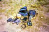 survey grade Pathfinder PRO XRS GPS
receiver programmed to record a position every second as the trail was either
hiked or mountain biked. In all, over 466,000 positions were measured in either 1
or 5 second intervals. The
positions were then differentially post-processed using data from another GPS unit running at a
known location. The resulting trail alignment is stunning in it's detail
and accuracy.
survey grade Pathfinder PRO XRS GPS
receiver programmed to record a position every second as the trail was either
hiked or mountain biked. In all, over 466,000 positions were measured in either 1
or 5 second intervals. The
positions were then differentially post-processed using data from another GPS unit running at a
known location. The resulting trail alignment is stunning in it's detail
and accuracy.
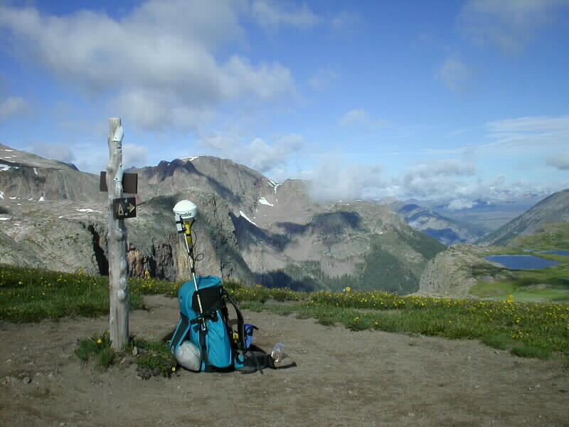 As
the photos on the right and left show, the GPS gear is bulky and fairly
heavy. It takes about seven pounds of batteries to run the equipment for a
day. Wilderness areas without ready access present interesting
challenges. The La Garita Wilderness section of the Colorado Trail
required four days and 28 pounds of batteries! The GPS collects
massive amounts of data, resulting in extraordinarily good maps. We use
only top quality professional grade equipment. More
photos here: Colorado Trail Photo Gallery
As
the photos on the right and left show, the GPS gear is bulky and fairly
heavy. It takes about seven pounds of batteries to run the equipment for a
day. Wilderness areas without ready access present interesting
challenges. The La Garita Wilderness section of the Colorado Trail
required four days and 28 pounds of batteries! The GPS collects
massive amounts of data, resulting in extraordinarily good maps. We use
only top quality professional grade equipment. More
photos here: Colorado Trail Photo Gallery
The Colorado Trail Foundation conducts annual treks, provides outdoor workshops, and works relentlessly to improve and maintain the way. Their success was largely due to the efforts of Gudy Gaskill, who spent much of her adult life making it a reality. Gudy is still around, running the nature studies workshops from the foundation's nature studies center near Section 22 of the trail.
Check out the Igage Mapping Corporation website for map examples and to see some photos from the project. Check out The Colorado Trail Foundation website for more photos, or to order the CD, guide books, etc.
The Maps Have Really Changed!
There
are areas where the original trail line was drawn hundreds, even thousands of
feet from where the trail actually is. This was due to poor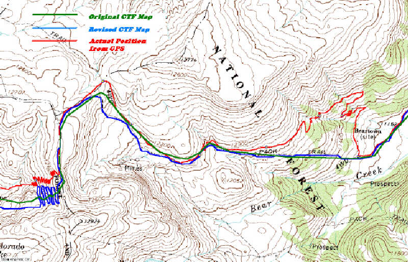 positioning on the
original maps, and to re-route work done by the CTF. Some of the old routes are
still clearly identified on the
topographic maps as the Colorado Trail. The most glaring example is in section
6, where the route is identified on the topographic map following a jeep road
along the Swan River. This was the location of the route when the map was
revised in 1987, but not where it is today. Now the route runs north of the
topographic map position by as much as two miles. In the example to the
right, in section 24, the trail actually runs nearly 1/2 mile north of the old
map positions. The black line is where the trail really is. For the
first time, backcountry travelers will have truly accurate maps to navigate
by.
positioning on the
original maps, and to re-route work done by the CTF. Some of the old routes are
still clearly identified on the
topographic maps as the Colorado Trail. The most glaring example is in section
6, where the route is identified on the topographic map following a jeep road
along the Swan River. This was the location of the route when the map was
revised in 1987, but not where it is today. Now the route runs north of the
topographic map position by as much as two miles. In the example to the
right, in section 24, the trail actually runs nearly 1/2 mile north of the old
map positions. The black line is where the trail really is. For the
first time, backcountry travelers will have truly accurate maps to navigate
by.
Update: Trail re-surveyed (Denver to Durango) by J. Brown in 2004 using a Thales Mobile Mapper.
Update: Third survey and signage inventory done by J. Brown and brother Carl in 2007 using Thales Mobile Mapper.
The Durango Nordic Center contains 16K of groomed XC and skate track. The center is located on property owned by Durango Mountain Resort at Purgatory. It is the training site for Durango area junior Olympians and hosts several competitions each winter. We GPS'd the track this summer to help determine the exact lengths of all the circuits to assist in the design of races. To print your own map, click on the image to enlarge, then print with your browser's print command. The image is sized to print on a 8.5 X 11 inch printer.
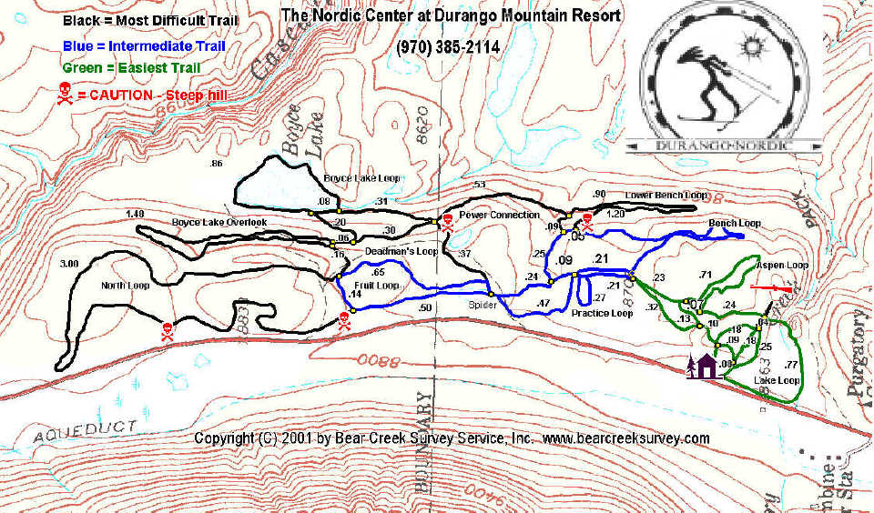
click on image to enlarge
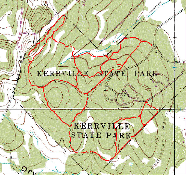 Maps of Kerrville State Park in Kerrville, Texas were completed
in January, 2001 for the Kerrville Bicycle Club and Friends of Kerrville
Schreiner State Park. The maps are being used for planning,
construction, and rehabilitation efforts for the trail system within the
park. The field work was done by Richard Nolde and Susan Junkin,
both board members for The Colorado Trail Foundation
while they were on a visit to the area. Bear Creek post-processed the data
and created the maps using images donated by Igage
Mapping. None of the parties received compensation - this was a
done as a contribution and as a thank you to the bicycle club, who's members
provided help for the Colorado Trail project.
Maps of Kerrville State Park in Kerrville, Texas were completed
in January, 2001 for the Kerrville Bicycle Club and Friends of Kerrville
Schreiner State Park. The maps are being used for planning,
construction, and rehabilitation efforts for the trail system within the
park. The field work was done by Richard Nolde and Susan Junkin,
both board members for The Colorado Trail Foundation
while they were on a visit to the area. Bear Creek post-processed the data
and created the maps using images donated by Igage
Mapping. None of the parties received compensation - this was a
done as a contribution and as a thank you to the bicycle club, who's members
provided help for the Colorado Trail project.